Our Projects

GIS

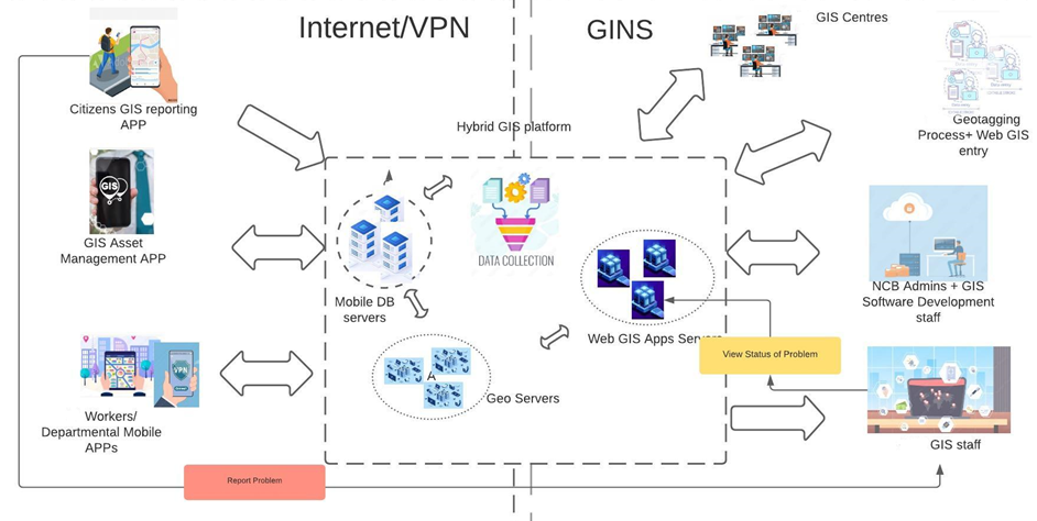
GIS, or Geographic Information Systems, are IT  tools to store locations, visualize them on a map, analyze, and interpret geographic or spatial data. GIS are in use in Mauritius by several Institutions,  most often with commercial ArcGIS tools.

MDPA successfully set up a National GIS (NGIS) Platform,  a precursor in Mauritius for this technology for public sector. The NGIS operates on Open Source QGIS with reduced cost benefits.

The benefits of the NGIS are:

  • Shared infrastructure and software
  • Data shared among stakeholders (R, RW access)
  • Cost of ownership lowered
  • Open Source QGIS v/s commercial ArcGIS
  • Inter operability of data, reduce Silos
  • sharing of knowledge and best practices
  • Avoid duplication of data entry across many agencies

Projects being implemented

GIS Assets system was developed as pilot for District Council Moka and subsequently replicated for all 12 Local Authorities (Municipalities and District Councils). The system allows to be mapped, visualized, analysed, helping Management to make quick informed decisions for maintenance, repair or replacement. 

Assets being monitored include roads, drains, electric poles, buildings, amenities, projects. GIS System was implemented as Open Source leading to large cost savings as compared to license & development cost for commercial applications. 

A Mobile App was also developed to allow mapping of assets by field officers with accurate GNSS precision. 

MDPA is also working with the Ministry of Environment t for the setting up of a “Web GIS Interface for Environmental Planning”  to enable remote access and viewing of all their GIS data and layers by non-technical Management staff for planning and decision making.